Overview
Distance: ~11 miles round trip
Elevation: 5555 ft to 11253 ft = ~ 5700 ft
Time: ~10 hours (round trip)
Date: June 16, 2012
How to get there from BYU:
View Larger Map
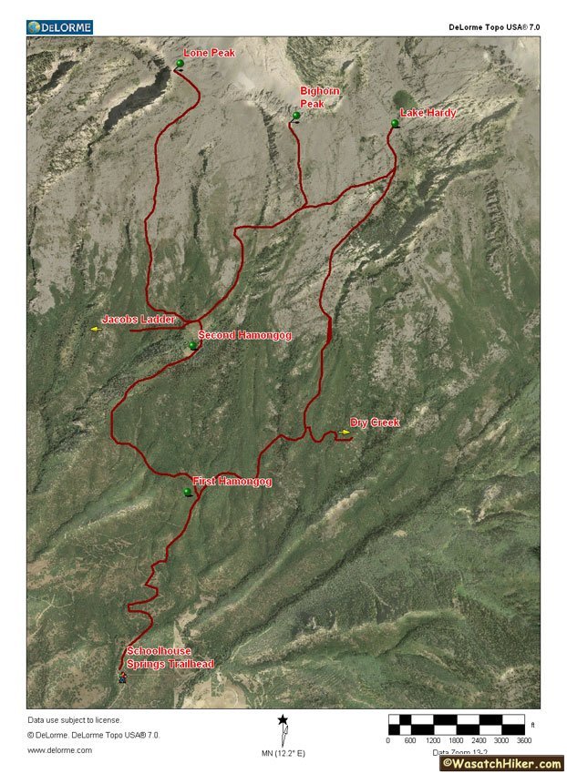
Map:
Description:
Peak hikes can be very exhilarating. Something about reaching the top of a mountain that makes you feel like you can accomplish anything. It also comes with great views -- and plenty of sore muscles. Lone Peak, with it's daunting cliffs at the top, is just such a peak. The mountain itself is named Mount Jordan of which Lone Peak is the top.
 |
| Lone Peak from Lindon |
The star of this hike was Uncle Bob. He's been to the top quite a few times and agreed to be my guide on this journey. And despite stating that he hadn't been on a good hike in years he still outpaced me with no trouble.
As this is a very long hike, you will want to start very early. We got started about 5:30 AM and made it back down about 3:30 PM. There are plenty of good camping spots at the second hamongog if you want to break it into two days and give yourself a breather.
 |
| Mt. Nebo in the morning |
 |
| mountain shadow over Lehi |
The trail starts near some water towers on the edge of Alpine. There are other trails more popular than this one for going up. The alpine trail can be a bit steeper but is also fairly straightforward to follow. The trail starts out with a very well defined dirt road. There are various smaller roads that may provide shortcuts but generally aren't worth it -- as we discovered :-).
 |
| Switchbacks |
 |
| private property - don't go that way (go right) |
The dirt road does switch backs for the first couple miles up to the Lone Peak Wilderness . It used to be that the road was blocked as it went through private property. But good legal action helped to open up the switchbacks to hikers -- as long as you stay on the road. The old shortcut was very steep and slippery - though significantly shorter. I marked the old path in read on the map above.
 |
| The old steep way |
 |
| Almost finished the switchbacks |
Once you make it to the Lone Peak Wilderness you will see the first hamongog (~7000 ft). "hamongog" comes from a reference in the Bible (i.e. "the Valley of the multitudes of gog") but in this instance it is used to mean meadow -- weird, but it's fun to say.
 |
| It's a sign! |
 |
| the first hamongog |
 |
| Go left when the trail splits (right to Lake Hardy) |
 |
| Looking up to our destination |
The trail continues from here for another mile and a half to the second hamongog (~8000 ft). The trail narrows to the standard single-file mountain trail as it passes through some nice trees and climbs up into the evergreens.
 |
| I was walking through the woods one day |
 |
| near the second hamongog -- those are huge boulders |
We saw a lot of people camping by the second hamongog. There's lots of nice areas under the evergreens (spruces I think.) This is a great place to take a rest before attempting the much more challenging second half of the hike.
 |
| Hamongog! |
 |
| Uncle Bob shows the way -- don't go right! (to Lake Hardy) |
 |
| So close but so far away |
 |
| a nice stream going through the area |
Only about 2 more miles to go but you must climb 3000 ft over that distance to the top. After leaving the meadow the trees quickly disappear. You will often see cairns (i.e. piles of rocks) to help guide after this point though they tend to be so far apart that their not really that helpful.
 |
| Hi Cairn |
 |
| Another split in the trail. Go right this time -- up! |
The trail begin to follow a fairly steep gully at this point. It's easier to go up than it is to go down. Much of it is covered in the granitoid rocks that provide a fair amount of grip as long as you avoid the water which can make it slippery. Going down I made good use of my hiking pole.
 |
| A pretty little water flow |
 |
| Hey, where'd the dirt go? |
Once out of the gully the hike becomes less treacherous and more of an endurance challenge. You enter into a large open field of grass, brush, and rocks. The trail all but disappears at this point and you can choose whichever path works for you. You can make your own switchbacks or push straight up the hill. It's not so steep that you worry about falling but it will wear you out for sure. I found that it was kind of like going up a set of stairs for about 3000 feet.
 |
| Choose your own adventure |
 |
| Looking back at the second hamongog |
 |
| One step at a time |
 |
| The rocks start getting a little bigger as you go up |
As you go further up, begin veering towards the cliffs at the right as there are cliffs blocking the path to the left. This will bring you up to the ridgeline. Be careful of snow fields. Depending on the time of year there could be a fair amount up here. Some parts can be quite solid while you'll sink right into other patches of snow. I used my hiking pole to help test where I was stepping.
 |
| There was a mountain goat there a second ago... |
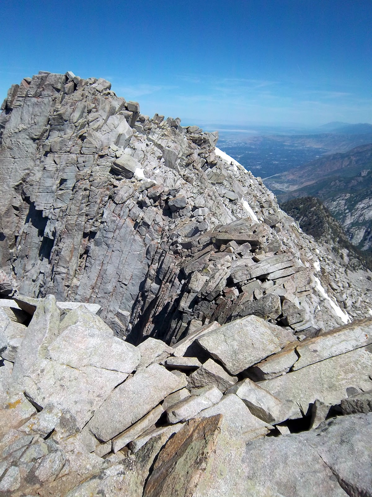
Higher up towards the ridge the rocks began to get bigger. Don't be in too big a rush. There are plenty of options for climbing up through it. You may have to use your hands to climb here and there. The white granitoid rocks along with the snow can be very bright later in the day. It may help to have some sunglasses in this area.
 |
| Hmmm...do we need to cross the snow? |
 |
| The southern peak from near the ridgeline |
 |
| looking over the ridge towards Salt Lake City |
 |
| doesn't look like much further to go |
Once we got to the ridge we discovered that the boulders were a little too big for comfort so we went down a short distance and found a path just below the ridge heading west. After this it was just a couple hundred feet through another rocky field to the top.
 |
| heading west below the south side of the ridge |
 |
| Cool weather on this rock |
 |
| Uncle Bob got there first |
Once we got to the top of the hill I discovered that this wasn't the true peak after all and was a miniscule 25 ft short of our goal. Many people stop here as the path to the true peak can be a bit treacherous and the view is amazing from this point. Definitely worth a few minutes to take it all in.
 |
| There's actually someone climbing that cliff near the lower center |
 |
| Oh man. We're not at the true peak |
 |
| Not for the faint of heart |
The rest of the way to the true peak is requires a steady heart and hand as you must climb over some car size boulders over a narrow ridge with 500 ft cliffs to one side. Uncle Bob was a good guide and found a not-as-treacherous path to the top. You must first descend a little and then back up the peak. I would highly suggest not going at this alone.
 |
| Near the narrow neck. It's a long way down |
 |
| Going back up again |
 |
| Just a little further along the top of these rocks |
As expected the top provided amazing views all around. I could see all the way to Syracuse in the north, Nephi in the south, far out into the desert to the west, and the Uinta mountains to the east. There's a US flag up there as well as a survey marker to take a picture with -- which you'll need to do for the geocaches.
 |
| Uncle Bob with the US Flag |
 |
| That pole was a lifesaver! |
 |
| That last step is a doozy |
 |
| Looking back at the false peak -- compare the cliff to the people on top |
 |
| I can see my parent's house in Syracuse! |
 |
| Lehi and the wilderness |
 |
| More than one person left their mark |
This says 11251 but there's a rock above it that will give you 2 extra feet!
Going back down went significantly faster (3 hours versus the 6 it took us to go up.) My pole once again came in handy to help relieve my knees from the constant descent. Judge your path carefully and you should be able to avoid the largest obstacles. The day was getting pretty bright and hot by this point and the small patches of trees were a great blessing as well.
 |
| Going back down |
 |
| If I can just make it to that tree... |
 |
| Looking back over Utah Valley on the way back |
Geocaching:
There are not many caches along this route. Most of the trail is in the Lone Peak Wilderness area which, apparently, is off limits to caches. However, that didn't stop there being two "virtual" caches at the very top. Take you picture at the top and they're yours. There's one other just before reaching the wilderness area but it requires a bit of scrambling through the brush to get too -- may want to get this one on a day you're not planning on going all the way to the top.


 Lone Peak

No comments:
Post a Comment